Ganga has been called as the tirath of kaliyug. This tirath is fast receding. It is said that once Ganga retreats completely, kaliyug will end a few years after that. In this series of articles, we will attempt to trace the epic journey of Ganga, from Gaumukh to Gangasagar. Har Har Gange!
Ganga descends on earth from heaven

According to Ramayana, King Bhagirath performed severe penance for over thousand years and earned a boon from Lord Brahma to bring Devi Ganga on earth to facilitate the release of his cursed ancestors. The force and volume of Ganga could not have been borne by earth, and so King Bhagirath propitiated Lord Shiv for help. Lord Shiv then held Ganga in his locks, from where she is believed to flow on earth till date with a gentler flow. Ganga then flowed from north through east into the ocean, washing away the sins of his ancestors. Because of his unparalleled contribution in blessing the earth with the force of Ganga, the river is called Bhagirathi from its origin till it meets Alaknanda at Devprayag, thereafter she flows as Ganga…
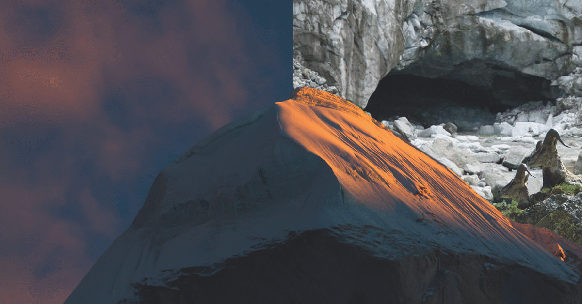
Gaumukh, mouth of the Cow
At the height of 13,200 ft from sea-level, in the district of Uttarkashi (Uttarakhand), where the second largest glacier of India reaches its extreme, lies the point where Ganga starts its journey on earth. The tunnel created in the block of ice by the force of flowing water, resembled* the mouth of a cow, and hence is called Gaumukh. Ganga as it flows out of the Gaumukh is called Bhagirathi.
(*In 2013, due to a cloud burst in Uttarakhand, huge cracks had emerged on the glacier. On July 26, 2016, following heavy rains in Uttarakhand, it was reported, the front end of Gaumukh was no more, as a large chunk of the glacier had collapsed and was washed away.)
HOW TO REACH?
It is an 18km trek, starting from Gangotri, which is the last place on the route accessible by roads.
- Gangotri – Chirbasa: 9 km ahead of Gangotri is Chirbasa, the abode of Chir trees.
- Chirbasa – Gila Pahar: After 3 km of Chirbasa comes the dangerous Gila Pahar, the place well known for its landslides even prior to the 2013 destruction Of much of the trail here; near-sheer cliffs down to the river must now be traversed. Here the Bharals, a type of mountain antelope are sometimes seen.
- Gila Pahar – Bhujbasa: 4 km ahead is Bhujbasa, the only night halting place enroute. The route after ‘Bhujbasa’ can be quite difficult, more so since the 2013 floods. One has to cross a boulder zone to reach the Gaumukh snout.
- Bhujbasa – Gaumukh: After trekking 4.5km from Bhujbasa, one reaches Gaumukh. A little before Gaumukh, the majestic view of Mt. Shivling welcomes the trekker. On the trail, no horses are allowed. The trek to Tapovan and Nandanvan starts from here.
The forest for penance, Tapovan
Traditionally, any place where a sadhak has performed rigourous penance and practice, is called a tapovan, even if there is no ‘van’ (forest). One extremely potent tapovan lies at the foot of the Shivling peak, above the Gangotri glacier, beyond Gaumukh at an elevation of 14640ft. The area is full of meadows, streams and flowering plants. It also serves as base camp for journey higher to the peaks…Shivling, Bhagirathi etc.
HOW TO REACH?
- Gaumukh – Tapovan: The trek beyond Gaumukh is quite difficult. Crossing the glacier & going towards Tapovan has become quite dangerous, more so after 2013 landslides. There is no track and one must have a guide and be prepared for all kinds of adversities. The last climb to reach Tapovan is very steep, a 2 km climb of around 1500ft!
Nandanvan
Situated at an elevation of 14640ft from sea-level, Nandanvan forms the foot of the Bhagirathi peak.
HOW TO REACH?
- Tapovan – Nandanvan: The 7km trek involves a steep descent from Tapovan to Gaumukh followed by a steep climb of about 100mt to reach Nandanvan.
Read our next issue for Gangotri travel diaries.
Receding Goddess: Environmental Alert!
- According to a BBC report on 27th July 2016, the gaumukh is now almost closed due to a landslide in the region. The water stream of the Bhagirathi that had originated from the source of the Ganga at Gaumukh has shifted 50 metres to its left and is at present flowing out of the Chaturangi glacier instead of the Gangotri glacier. Heavy boulders of rock and snow have shut the snout of the river at Gaumukh.
- The Gaumukh snout is rapidly moving backwards. According to modern research the snout has moved 1 km in just 70 years.
- During the Kedarnath tragedy, the Gaumukh had developed serious cracks and has now given away.
- For the first time in 50 years, the water has reached the “Bhagirathi shila” that stands a few feet below the Gangotri temple. The water had not reached this point even during the Kedarnath tragedy.
Editor’s Note
A word of caution, these places are not for tourism and must not be frivolously approached for “fun”.
The energies in these places are conducive for sadhaks and those treading the path of their Guru to further their own spiritual journey on the path. If they are used for social outings then you will disturb the energies there and bring misfortune to yourself. The various calamities that happen at such places are ample proof of this.
These places are for vairagya and moksh, not for fun and games.If you want to complete a sadhna without disturbances for your spiritual evolution, then these places are ideal for you.
Author: Gauri Rathore